Meteorological environment monitoring equipment supplier
Insist on doing high-precision customer favorite technology products

Meteorological environment monitoring equipment supplier
Insist on doing high-precision customer favorite technology products

1. Product introduction of radar surface flow velocity measurement system
The radar surface flow velocity measurement system is also called radar online flow measurement system and radar wave flow measurement system. The radar surface flow velocity measurement system mainly uses microwaves to measure the surface flow velocity of rivers, mud, sewage, etc., and can be detected in rivers and irrigation areas. flow. The FT-ML3 radar surface flow velocity measurement system is a fully automatic flow telemetry system that can monitor the entire open channel water flow process. This flow measurement system is not affected by temperature, humidity, rainfall, water depth, muddy water, and floating objects on the water surface. It is very suitable for flow testing under water conditions in open channels such as irrigation areas and rivers.
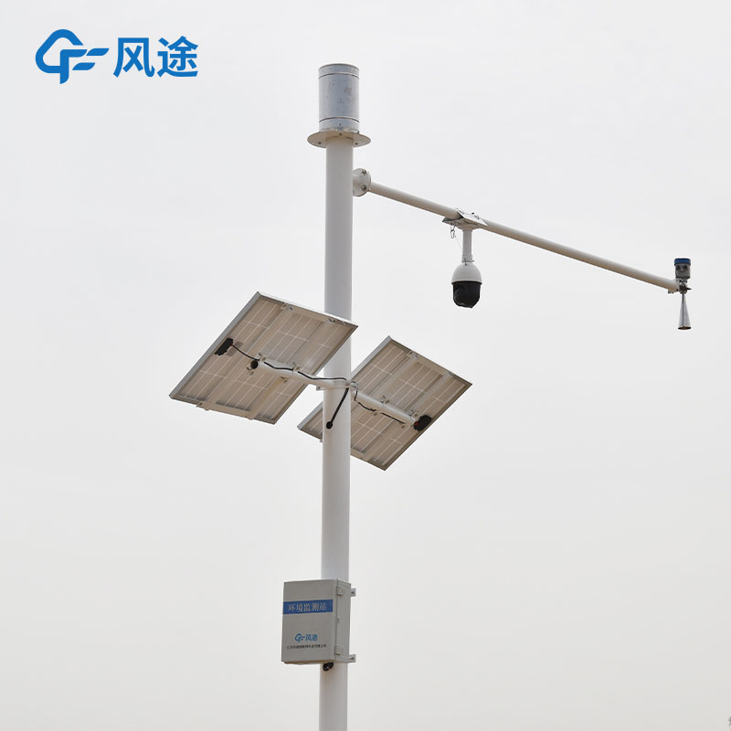
2. Components of radar surface flow velocity measurement system
Main components
(1) Three-in-one radar water level, surface velocity and flow rate;
(2) Telemetry terminal RTU;
(3) Solar power supply system;
(4) Pole and bracket;
(5) Lightning protection and grounding.
3. Working principle of radar surface flow velocity measurement system
The radar surface velocity meter is based on the principle of pulse radar technology to measure the surface flow velocity of the river water body. It is used in conjunction with the radar water level sensor and is installed at regular sections of open channels such as rivers and irrigation areas to calculate the flow, that is: at the regular section, the measured The speed of the water flowing through the section is measured, and the depth of the water body is measured at the same time. The flow rate of the water flowing through the section is calculated through mathematical geometric principles.
4. Characteristics of flow measurement station of radar surface flow velocity measurement system
The main feature of the radar surface flow measurement system is to measure flow in a non-contact manner. It mainly consists of a set of three-in-one radar water level, flow, velocity and flow sensors. It is suspended above the channel through pole erection. By measuring the water level, depth and instantaneous measurements of regular sections The surface flow velocity is measured and the flow rate passing through the section at this moment is calculated. The main features are as follows:
(1) Advantages
It adopts non-contact type, can be installed with water, and is not restricted by channel flow and water accumulation;
No water blocking phenomenon;
Not easily affected by debris and floating objects in the channel;
Not affected by water quality and sediment content;
Suitable for channels with fast flow speed and large traffic.
(2) Interference factors
Influence of wind speed: Wind speed can easily cause fluctuations in the water surface, resulting in false alarms and mismeasurements;
Slow flow speed: When the water surface flow speed is slow, the measurement error increases;
Windy and sandy weather: Windy and sandy weather has a greater impact on the signal strength of radar waves, resulting in larger measurement errors;
Heavy rainfall: When encountering heavy rainfall, radar waves are easily affected by the intensity of the rain, resulting in larger measurement errors.
5. Technical parameters of radar surface flow velocity measurement system
water level measurement
Ranging range: 0.4-40 meters
Distance measurement accuracy: ±1cm
Ranging resolution: 1mm
Interval time: 1-5000min
Flow velocity measurement
Range: 0.15~15m/s
Speed measurement accuracy: ±2%
Speed resolution: 0.01m/s
Flow measurement
Flow rate = average flow velocity x flow cross-sectional area x correction coefficient
The average flow velocity is collected by the flow meter and calculated by the model.
The flow cross-sectional area is calculated from the water level measured by the water level gauge and the cross-sectional information.
Sales Manager:Ms. Emily Wang
Tel, Whatsapp:+86 15898932201
Email:info@fengtutec.com
Add:No. 155 Optoelectronic Industry Accelerator, Gaoxin District, Weifang, Shandong, China


 Get a Free Quote